We Arkansans are blessed with some of the most stunning and diverse hiking experiences in the country. With lush forests, rolling hills, sparkling lakes, and some minor mountains, Arkansas provides a scenic backdrop for hikers of all levels. The state boasts a rich biodiversity and varied terrain, making each hike unique. The best hikes in Arkansas are well-maintained, often featuring historical landmarks and educational opportunities. Whether you’re an experienced hiker seeking challenging trails or a beginner looking for a leisurely walk through nature, Arkansas has something for everyone!
The Best Hikes in Arkansas

While researching the highest-rated hikes in the Natural State, I was pleasantly surprised with a walk down memory lane as I saw that most of my personal favorites were on the list. As a born and bred Arkansan and an avid hiker, I can truly say that Arkansas has some great trails.
No…the mountains don’t compare to the epic hikes of the Pacific Northwest, the Alps, or the Himalayas, but I can tell you that I have enjoyed some of these hikes just as much as I did traversing those big boys.
Here are a few of the absolute best Arkansas hikes according to me (and All Trails)—where I gathered all the stats for each hike.
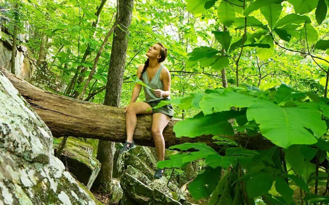
1. Whitaker Point (Hawksbill Crag) Trail
Location: Ponca, AR
Length: 2.7 miles (out and back)
Difficulty: Moderate
Parking: At the trailhead and along the road
Estimated Hiking Time: 1.5 hours
What You’ll See:
Whitaker Point Trail, also known as Hawksbill Crag, is one of the most photographed spots in Arkansas. The trail offers stunning views of the Ozark National Forest and features a rock outcropping that juts out like a hawk’s beak.
Along the way, you’ll pass through dense forests and may encounter wildflowers, small creeks, and diverse wildlife. The highlight is reaching the crag itself, which provides panoramic views of the surrounding mountains and valleys. It’s an epic spot for photos!
Tips for Hiking:
- Start early to avoid crowds, especially on weekends.
- Be cautious near the edges of the crag, as there are steep drop-offs and no barriers.
- The road to the trailhead is gravel. If you enter from the north near Ponca, it’s a fairly nice drive. If you come from the south, you will need an SUV or higher clearance vehicle as the road is dirt and prone to potholes.
- Cell phone service in the area is spotty. Download a trail map before your trip.
- Watch out for poison ivy!
2. Lost Valley Trail
Location: Ponca, AR
Length: 2.3 miles (out and back)
Difficulty: Easy to Moderate
Parking: Large lot at the entrance
Estimated Hiking Time: 1 hour
What You’ll See:
Lost Valley Trail is perfect for families and beginners. It’s one of my favorite trails in Arkansas because it’s not so much a straight trail as a scramble over natural bridges, ancient caves and rock shelters, and trickling waterfalls. The trail meanders through a lush valley, and it feels magical.
The main highlight is Eden Falls, a 53-foot waterfall that cascades into a serene pool. However, in the summer months, the waterfall is generally a trickle at most.
If you’re adventurous, bring a flashlight and crawl through the low entrance to Eden Falls Cave, one of the best caves in Arkansas. When you arrive at the end, the cavern opens into a towering space with its own waterfall and gloriously cool temps. It’s definitely worth the crawl if you’re not claustrophobic.
Tips for Hiking:
- Bring a flashlight if you plan to explore the caves.
- Check the weather beforehand; the trail can be slippery after rain.
- Pack a picnic to enjoy near the waterfall area.
- Keep a close eye on small children and pets. There are many fall hazards.
3. Glory Hole Waterfall Trail

Location: Between Arbaugh and Deer, AR
Length: 1.9 miles (out and back)
Difficulty: Moderate
Parking: Just off Hwy 16
Estimated Hiking Time: 1 hour
What You’ll See:
Trucking down the road a bit, still in the Ozark National Forest, we land at an unfortunately named natural phenomenon. The Glory Hole Waterfall Trail is renowned for its unique geological feature—a waterfall that has carved a hole through a rock shelf, creating an odd and fun water feature.
The trail descends through a forested area on an old Jeep path, eventually leading to the waterfall. The hike itself is relatively short but includes some steep sections and can be slippery in the rainy season. Along with the waterfall, you’ll get to explore a large natural bridge from a fallen tree and absolutely gigantic climbing stones that provide hours of fun!
Tips for Hiking:
- Best visited after a rain to see the waterfall in full flow.
- Wear appropriate footwear for navigating rocky terrain.
- Be prepared for a steep climb back to the trailhead.
4. Hemmed-In Hollow Trail

Location: Compton, AR
Length: 5.7 miles (out and back)
Difficulty: Hard
Parking: Trailhead
Estimated Hiking Time: 3 hours
What You’ll See:
Hemmed-In Hollow Trail is a challenging hike. However, you’ll be rewarded at the end with the tallest waterfall between the Rockies and the Appalachians. The 209-foot Hemmed-In Hollow Falls is not a roaring falls, but it is tucked into a lovely cove with a flowing stream and plenty of picnic spots.
The trail descends steeply into the Buffalo River Valley, passing through lush forests, and includes a good number of stairs. The return hike is strenuous due to the elevation gain (1,420 ft). You can also reach this waterfall via a short and easy trail from the river if you’re kayaking on the Buffalo!
Tips for Hiking:
- This trail is best suited for experienced hikers.
- Start early.
- Bring plenty of water and snacks to keep your energy up.
- No dogs allowed
5. Cedar Falls Trail
Location: Petit Jean State Park-Morrilton, AR
Length: 1.9 miles (out and back)
Difficulty: Moderate
Parking: Large lot at the Visitor Center near the trailhead
Estimated Hiking Time: 55 mins
What You’ll See:
Cedar Falls Trail in Petit Jean State Park is one of the most popular hikes in Arkansas. Start your hike in front of the Visitor Center and take in the astounding view from the overlook. The center offers a swimming pool, several hikes, picnic areas, and much more!
Cedar Falls Trail leads to the spectacular 95-foot Cedar Falls, one of the highest continuously flowing waterfalls in the state. Along the way, you’ll hike through scenic canyons and along the creek. Bring a swimsuit and cool off in the pool at the base of the falls.
Tips for Hiking:
- Check for water levels at the falls; they can vary significantly with the seasons.
- Wear sturdy shoes as the trail can be rocky and uneven.
- Plan to spend several hours. The park has a lake, numerous trails, and plenty to keep you busy all day.

6. Mount Magazine Signal Hill Trail
Location: Paris, AR
Length: 1.5 miles (loop)
Difficulty: Easy
Parking: Large lot at the Visitor Center and parking at the campground
Estimated Hiking Time: 45 mins
What You’ll See:
This one makes the list more for nostalgia and bucket list purposes than views. Signal Hill Trail takes you to the highest point in Arkansas at the peak of Mount Magazine, standing at 2,753 feet above sea level. The trail is relatively short and offers a gentle hike through deciduous forests, however…there are no views.
At the summit, you’ll find a marker indicating the highest point, surrounded by a small clearing. The area is also known for its diverse wildlife and seasonal wildflowers, and you can cool off in nearby Cove Lake after finishing your hike!
Tips for Hiking:
- Suitable for all ages and skill levels.
- Combine this hike with other trails in Mount Magazine State Park for a full day of exploration.
- Visit the lodge or picnic areas for a relaxing break.
7. Richland Creek Wilderness Area – Twin Falls Trail
Location: Witts Springs, AR
Length: 4.6 miles (out and back)
Difficulty: Moderate
Parking: Campground at the trailhead
Estimated Hiking Time: 1hr 45 mins
What You’ll See:
This trail in the Richland Creek Wilderness Area offers a rugged and remote hiking experience. It leads to the scenic Richland Falls (if you take the south bank trail) and the Twin Falls, both of which are beautiful and less crowded than other waterfalls in the state. The hike involves deep river crossings, rocky terrain, and navigating through dense forests, making it a challenging adventure.
As you’ve probably guessed, this trail is for seasoned hikers. Though it isn’t technically difficult, the trail is not well marked, you may need to bushwhack, and the river crossings can be waist-deep in the rainy season.
Tips for Hiking:
- Best suited for experienced hikers due to the difficulty and length.
- Be prepared for multiple river crossings; bring water shoes if needed.
- Download the route beforehand as the trail can be hard to follow in places. Cell service is spotty.
- You will need strong bug spray with DEET.
- Check for ticks after the hike.
8. Buffalo National River Trail – Indian Rockhouse Nature Trail
Location: Yellville, AR
Length: 3.1 miles (loop)
Difficulty: Moderate
Parking: Small parking across from the trailhead
Estimated Hiking Time: 1hr 20 mins
What You’ll See:
The Indian Rockhouse Trail is a historical and scenic hike that leads to a large rock shelter used by Native Americans. The trail features a variety of interesting geological formations, including a waterfall, sinkholes, and a small cave. The Indian Rockhouse itself is a massive cave-like structure that lets you imagine living in the stone age!
Tips for Hiking:
- Bring a flashlight for exploring the cave.
- The trail is well-marked, but be mindful of rocky and uneven sections.
- Enjoy a picnic near the Rockhouse for a unique experience.
- No dogs allowed.
9. Yellow Rock Trail

Location: Devil’s Den State Park, West Fork, AR
Length: 2.6 miles (loop)
Difficulty: Moderate
Parking: Small parking across from the trailhead, larger parking area at the park entrance
Estimated Hiking Time: 1hr 15 mins
What You’ll See:
Hawksbill Crag’s twin, Yellow Rock Trail is another epic craggy overlook and one of the most scenic hikes in the state. The trail offers stunning overlooks of the Lee Creek Valley, especially from the Yellow Rock Overlook.
Along the trail, you’ll also encounter beautiful rock outcroppings, small bridges, a diverse array of plant and animal life, and a few small creek crossings. Once you arrive at the pièce de résistance, there are two overlooks. The larger one on the right is broad, offering a safe space to view the surroundings, and is the best place from which to snap photos of loved ones who brave the Yellow Rock outcropping on the left.
Tips for Hiking:
- Visit during the fall for spectacular foliage views.
- Wear sturdy shoes as the trail has loose gravel and is uneven in spots.
- Bring a camera to capture the breathtaking vistas from the overlook.
- Plan to spend the full day in Devil’s Den State Park fishing and exploring the cave trails.
10. Eagle Rock Loop
Location: Ouachita National Forest, Glenwood, AR
Length: 26.6 miles (loop)
Difficulty: Hard
Parking: Small parking with campground and bathroom at the Little Missouri Trailhead, a lot at Albert Pike Rec Area, and several more spots along the trail (It has many possible trailheads).
Estimated Hiking Time: 11hr 40 mins, but most hikers choose to backpack it, spreading it out over a couple of days.
What You’ll See:
Our first Ouachita trail, Eagle Rock Loop is the longest and most challenging loop trail in Arkansas, offering a true wilderness experience. The trail combines portions of the Little Missouri Trail, Athens-Big Fork Trail, and Viles Branch Trail.
Hikers will traverse diverse landscapes, including high river crossings, mountain peaks, and dense forests. The loop offers stunning views of the Ouachita Mountains, numerous waterfalls, plenty of great campsites, and a variety of wildlife.
Tips for Hiking:
- ERL is best suited for experienced and well-prepared hikers and backpackers.
- Plan for a multi-day trip; there are several campsites along the loop.
- Be prepared for river crossings and steep ascents and descents.
- Carry a detailed map and compass; the trail can be difficult to follow in some areas.
- I suggest parking at the Little Missouri/Athens-Bigger Fork Junction and doing the ABF part of the trail first. It’s the hardest with 6 ridge climbs and hefty elevation change.
- Beware! Most parking in the area is not overnight, so make sure you check before you park!
11. Centerpoint to Goat Trail
Location: Ponca, AR
Length: 5.9 miles (out and back)
Difficulty: Moderate to hard
Parking: Free parking at the trailhead, $5 private parking across the road
Estimated Hiking Time: 3-3.5 hours
What You’ll See:
The Centerpoint to Goat Trail offers some of the best views of the Buffalo River and its surrounding bluffs. This one requires a little bit of bravery!
The hike starts at the Centerpoint Trailhead and follows a well-marked path through dense forest. The highlight is the Goat Trail, which follows a narrow ledge along Big Bluff, offering breathtaking views of the Buffalo River far below. It’s a very beautiful hike but should be approached with caution and not undertaken by anyone with a fear of heights.
You begin the trail by hiking downhill from the parking lot…which is nice! However, bring plenty of water for the trek back up because it’s…well…not so nice.
Tips for Hiking:
- Exercise caution on the Goat Trail, as the ledge can be narrow and exposed.
- Wear sturdy hiking boots for better traction.
- Bring plenty of water and snacks; the hike is lengthy and can be demanding.
- No dogs allowed
12. Pinnacle Mountain West Summit Trail

Location: Maumelle, AR
Length: 1.4 miles (out and back)
Difficulty: Moderate
Parking: Free parking at the base. Warning: Separate parking is available for East and West Trailheads.
Estimated Hiking Time: 1 hr 10 mins
What You’ll See:
The West Summit Trail at Pinnacle Mountain State Park is marked as challenging or hard in All Trails. I disagree with this one. It is uphill the whole way, but the trail is straightforward. There are some rocky stairs and a very small batch of boulders to maneuver towards the top, but even small children and healthy elderly hikers can maneuver it without difficulty.
The peak offers stunning views of the Arkansas River and the surrounding area. It feels like you can see the whole state from the top, making the effort well worth it. It’s a great spot for a picnic.
Local Tip: If you want a more fun and challenging hike, park in the East Summit lot and take the “backside” trail. This trail is a rock scramble for most of the journey. It requires sure footing, but it’s a blast. I took my 6-year-old niece, and she tackled it like a champ. If you’re afraid of heights, stay on the west side!
Alternative: Get a taste of both trails by ascending the east side and descending the west side. You’ll have to hike the Pinnacle Mountain Base Trail Loop to get back to your car.
Tips for Hiking:
- Wear sturdy hiking shoes with good grip.
- Start early to avoid the heat, especially in summer.
- Use caution on the rocky sections.
- Bring a picnic!
- Be patient. This is a very popular trail.
13. Devil’s Canyon Scenic Area Trail and Bushwack

Location: Mountainburg, AR
Length: 3.2 miles (loop)
Difficulty: Moderate
Parking: Free spot at the beginning of trail; Small dirt area on the right about 0.5 miles in with more parking.
Estimated Hiking Time: 1 hr 10 mins
What You’ll See:
This trail offers a rugged and scenic hike through the Devil’s Canyon Scenic Area. The route includes dense forests, rocky terrain, a long stretch of dirt road, and several stunning canyon views from the side trails. Then, you navigate the towering boulders and rock shelters of Fern Gully (yes, it’s really named Fern Gully, and it’s that lovely) until you reach the waterfalls and swimming area.
The trail is less developed and not marked, providing a true wilderness experience, but again, it’s doable. I took my young niece and nephew, and they loved this trail. Make sure to swim across the pool and stand under the small waterfall. From there, you can scale up the little ledge and walk along the creek on top of the waterfall!
Tips for Hiking:
- This trail is best suited for experienced hikers due to its rugged nature.
- Carry a detailed map and compass, as the trail is not well-marked.
- Be prepared for bushwhacking and navigating off-trail sections.
- GPS will bring you to the end of a dirt road with a bulldog mailbox. This is the start of the trail. There is one parking spot there. Continue up the dirt road for a 0.5 mile and there’s another dirt parking area for 3 to 4 cars.
- Do not drive past the parking area, unless you’re on an ATV!
14. Mount Nebo Rim Trail
Location: Dardanelle, AR
Length: 3.3 miles (loop)
Difficulty: Moderate
Parking: Visitor Center and Summit Park Trailhead
Estimated Hiking Time: 2 hrs
What You’ll See:
The Mount Nebo Rim Trail offers spectacular views from the top of Mount Nebo. The trail loops around the rim of the mountain, providing panoramic vistas of the Arkansas River Valley and a portion of the Trail of Tears. The hike is relatively moderate, with a few rocky sections. It also passes by several historical sites and educational signposts.
Tips for Hiking:
- Visit during sunset for breathtaking views.
- Be careful on the road up. It’s steep and consists of several hairpin turns.
- Wear sturdy shoes as some sections can be rocky.
- Bring a camera to capture the stunning vistas from the overlooks.
- Follow gold markers to stay on the Rim Trail.
15. Lover’s Leap Trail
Location: Queen Wilhelmina State Park, Mena, AR
Length: 1.1 miles (loop)
Difficulty: Moderate
Parking: Queen Wilhelmina Lodge
Estimated Hiking Time: 1 hour
What You’ll See:
Lover’s Leap Trail in Queen Wilhelmina State Park offers a short but scenic hike with beautiful views. The trail leads to an overlook with a great panorama of the Ouachita Mountains. The area is known for its rich history and scenic beauty, making it a favorite among history buffs. It’s also a popular trail with birders. The mountain is the second-tallest in the state and is often shrouded in fog, giving it a mysterious feel.
Tips for Hiking:
- Suitable for all ages and skill levels.
- Combine with other nearby trails for a full day of hiking.
- Enjoy a picnic at one of the park’s picnic areas after your hike.
Top Tips to Enjoy Your Hikes in Arkansas

1. Check the Weather: Arkansas weather can be incredibly unpredictable, especially in the shoulder seasons. Always check the forecast before heading out and be prepared for sudden changes.
2. Wear Appropriate Gear: Sturdy hiking shoes, comfortable clothing, and a hat are essential. Layer your clothing to adjust to changing temperatures. Closed-toed shoes are suggested, as Arkansas does have leeches, ticks, and poisonous snakes.
3. Stay Hydrated: Bring plenty of water, especially during hot summer months. A hydration pack can be convenient for longer hikes. The heat index in summer is always well above 100F. Do not underestimate it!
4. Use Sunscreen and Bug Spray: Protect yourself from the sun and insects by applying (and reapplying) sunscreen and bug spray. You will need something with DEET.
5. Follow Leave No Trace Principles: Respect nature by carrying out all trash, staying on designated trails, and not disturbing wildlife.
6. Plan Ahead: Research the trail beforehand. Many of the trails within the Ozark National Forest and the Ouachita National Forest do not have cell service. Know the length, difficulty level, and any specific challenges you might encounter. Download a map and turn on the location on your phone.
7. Tell Someone Your Plans: Let someone know your hiking plans, including your expected return time. This is crucial for safety, especially on longer or more remote hikes.
8. Pack Light, But Smart: Carry essentials like a first-aid kit, ample water, snacks, a flashlight, and a multi-tool. Keep your pack as light as possible to make the hike more enjoyable.
10. Respect Wildlife: Maintain a safe distance from animals and do not feed them. This helps keep both you and the wildlife safe. We do have black bears and snakes in Arkansas. You can consider carrying bear spray, but in general, it’s not necessary.
Final Thoughts on the Best Hikes in Arkansas

Arkansas offers a wide range of hiking opportunities, from easy, family-friendly trails to challenging, rugged adventures. The state’s natural beauty and diverse landscapes make it a hiker’s paradise. I’ve been blessed to hike all over the world, but honestly, Arkansas has a special beauty, and it’s meant to be explored on foot!
Whether you’re exploring the iconic Whitaker Point, getting doused by the unique Glory Hole, or reaching the highest point in the state on Mount Magazine, you’ll find that each trail has its own unique charm and beauty. Follow the tips for hiking in Arkansas and prepare properly so you enjoy a safe and memorable outdoor experience in the Natural State.
Happy hiking!
For more epic adventures in Arkansas, check out our the new articles in our travel blog! We’ve got new blogs on the best Native American sites in Arkansas, which summer camps to visit, and the most memorable summer events in the state for you to peruse!