
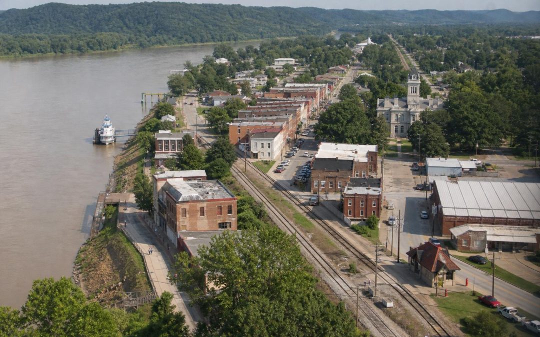
Before you study the buildings in an old Arkansas downtown, look at the streets.
Which way do they run? Where does Main Street lead? Is downtown stretched into a long strip beside railroad tracks, or do the streets seem to lean toward a riverbank?
An Arkansas town map is often a fossil of how people first arrived.
That is the idea I want you to carry on your next drive through the state. Riverboats pulled commerce toward the water. Railroads pulled it toward the depot. Even when the boats, warehouses, cotton platforms, and passenger trains are gone, the town usually remembers.
Once you learn to see that, an ordinary downtown walk becomes a treasure hunt.
Before You Read the Buildings, Look at Which Way the Town Faces
Arkansas was built around movement. Our rivers were the first great highways, carrying people, cotton, timber, livestock, mail, and news through a landscape where roads could be muddy, rough, or nonexistent.
A river town needed access to the landing. Streets often ran toward the bank or followed it. Businesses gathered where goods came ashore. The closer you were to the landing, the closer you were to the action.
Then the railroad arrived with a different set of rules.
A train did not care where the river landing had been. It needed a practical route, room for tracks, a depot, loading areas, and connections to farms, mills, and warehouses. New businesses lined up beside that transportation corridor. In some places, the commercial center moved. In others, a second downtown appeared.
This is why many Arkansas railroad towns feel long and narrow. Their business districts often run parallel to the tracks, with streets such as Railroad Avenue, Front Street, or Commerce Street offering a fairly obvious clue.
Follow the Clues From the Riverbank, Depot, Main Street, and Courthouse
Start at the transportation route and walk toward the center of town. You are following the same general path once taken by crates, passengers, salesmen, farmers, and mail sacks.
At the river
Do not expect the old landing to look dramatic today. Arkansas rivers move. Banks erode. Channels shift. Flood control projects change access. Levees and modern roads can hide the original relationship between town and water.
Batesville is a good place to practice. The White River explains why the town is there, even if modern traffic encourages you to think first about highways. Walk around the historic center, then go toward the river and notice how close the two worlds are. The river was not scenery. It was the connection to everything beyond town.
Helena offers an even bigger lesson. The Mississippi River made the place, while the levee now shapes how visitors experience it. Cherry Street and the surrounding blocks make more sense when you remember that Helena was tied to steamboats, cotton, railroads, and the immense movement of goods through the Delta.
Here is what most people miss: a river town may appear to turn its back on the water today. That does not mean it always did. Floods, levees, abandoned landings, and later development can hide the old front door.
At the tracks
In a railroad town, find the depot if it survives. Then stand beside it and look down the tracks.
You will often see the town stretched out in both directions. Warehouses occupy larger lots. Commercial buildings sit close together nearby. Streets cross the rails at regular points. The depot may be slightly removed from the courthouse because transportation and county government were serving different purposes.
Walnut Ridge is especially fun for this. The rail lines are not a background detail. They explain the town’s shape and importance. The surviving depot, now connected with local history and the town’s Beatles story, gives you a clear place to begin reading the landscape.
Hope is another good example. Stand near the historic depot and look at how downtown gathers around the rail corridor. The buildings make more sense when you picture passengers stepping off trains and freight being transferred into town.
At the courthouse
Now walk toward the courthouse. Arkansas courthouse squares often create a second center of gravity.
The depot brought goods and travelers. The courthouse brought attorneys, jurors, politicians, farmers recording deeds, and families conducting county business. Shops, banks, hotels, and restaurants benefited from both.
If the courthouse square sits several blocks away from the tracks, that distance can tell a story. Perhaps the town already existed before the railroad arrived. Perhaps civic leaders wanted government buildings away from smoke and noise. Perhaps commercial activity simply grew between the depot and the square.
Do not assume a slightly awkward street pattern is poor planning. It may be two different versions of town stitched together.
Here’s Where It Gets Interesting: Towns Shaped by Both River and Rail
Arkansas rarely gives us perfectly tidy examples. That is part of the fun.
Van Buren began with the Arkansas River, then became an important railroad town. Walk Main Street toward the river and you can feel both stories at once. The courthouse pulls your attention inland. The old commercial blocks lead you toward the lower end of town. The depot and tracks add another transportation layer near the river.
Fort Smith works the same way on a larger scale. Its river location mattered first, but railroads, military roads, industry, and later highways kept reshaping the city. If you only visit the historic buildings without walking toward the Arkansas River, you miss the reason the place exists where it does.
Little Rock may be the biggest Arkansas example of overlapping patterns. The Arkansas River, old landings, rail corridors, streetcars, government buildings, and modern highways all left marks. Downtown can feel complicated because it is complicated. Each transportation age added another layer without completely erasing the last one.
Plan a Two Town Road Trip and See the Difference for Yourself
For a simple Arkansas comparison, visit Dardanelle and Russellville. They sit close together on opposite sides of the Arkansas River, but they teach different lessons.
Begin in Dardanelle. Go to the riverfront and look upstream and downstream before walking back toward downtown. The Arkansas River explains the town’s location, while the street plan, courthouse, and old business blocks show how civic and commercial life spread inland from that transportation route.
Then cross the river to Russellville.
In downtown Russellville, find the railroad corridor and the historic depot area along C Street. Notice how the commercial district relates to the tracks. Russellville existed before the railroad, but rail service helped redirect growth and gave the town a strong new spine. That makes it more interesting than a perfectly planned railroad town because you can see the adjustment.
- In Dardanelle: Look for streets leading toward the river and consider what the waterfront meant before modern bridges and highways.
- In Russellville: Walk parallel to the tracks and watch for old freight doors, warehouses, broad lots, and buildings designed around rail access.
- In both towns: Find the courthouse and ask why it sits where it does.
This is an easy outing, but do not rush it. The whole point is to slow down and notice the shape of each place.
The next time you pass through an Arkansas town, do not begin by asking what there is to see. Ask a better question:
How did people used to arrive here?
Find that answer, and the town will start explaining itself.