
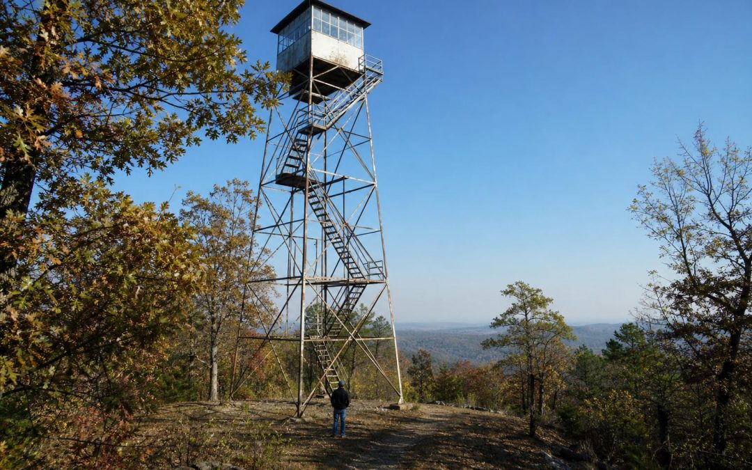
Stand beneath an old Arkansas fire tower and your eyes naturally go up.
You notice the narrow stairs, the tiny cab at the top, and the surprising amount of trust once placed in a person sitting high above the trees. If the tower is on a ridge, the view may stretch across miles of folded mountains that seem to have no end.
But here is the part I want you to imagine: that view was not scenery to the person working up there. It was a map of responsibility.
A thin smudge above a distant ridge could mean lightning, a brush pile, a campfire, or the beginning of something dangerous. The watcher had to notice it, estimate its direction, report it, and help crews figure out how to reach it through a maze of hollows and rough forest roads.
Once you understand that, Arkansas fire towers become much more interesting. They show us how people learned to watch over forests that once seemed far too large to manage.
Start With the View, Then Look for Smoke
Arkansas is especially good fire tower country because our landscape keeps hiding itself.
In the Ouachitas, long ridges run mostly east and west, stacked one behind another. In the Ozarks, steep hollows and broken plateaus can conceal a fire from anyone standing down below. Even Crowley’s Ridge rises high enough above the Delta to offer a very different kind of lookout.
A tower solved a simple problem: get above the trees and see farther.
Inside the cab, a watcher could use a circular instrument often called a fire finder to take a bearing on smoke. Another tower might report its own bearing. Where those lines crossed, crews had a much better idea where to begin looking.
That sounds straightforward until you look across an Arkansas forest and try to identify one particular hollow several ridges away.
Worth Noticing: When you visit a tower, study the land instead of only admiring the distance. Look for ridgelines, gaps, old roads, creek valleys, and places where smoke could disappear behind higher ground. You will quickly understand why tower placement mattered.
A Tower Was Only One Piece of the Network
The tower gets all the attention because it is the part we can still see. The real system was much larger.
Lookouts needed telephones or radios. Crews needed trucks, tools, maps, and passable roads. Forest agencies needed agreements about who would respond. Local residents also played a role by reporting smoke and helping crews navigate country that could be confusing even to people who knew it well.
This network grew as Arkansas was coming to terms with what had happened to many of its forests. Heavy logging, repeated burning, abandoned cutover land, and wildfire had left some areas badly damaged. The creation of the Ozark and Ouachita national forests, followed by more organized state forestry work, marked a change in thinking. Forests were no longer treated as endless.
They had to be watched, restored, and managed.
There is another detail worth understanding. Not every fire is the same. Today, carefully planned prescribed fire can improve wildlife habitat, reduce dangerous fuel, and help certain forest communities. That is very different from an uncontrolled wildfire on a dry, windy afternoon.
Modern detection relies on reports from the public, aircraft, cameras, weather information, and other technology. Many old towers were removed, abandoned, or closed. The ones still standing are reminders of the human eyes that once formed Arkansas’s early warning system.
Arkansas Fire Towers Worth Seeking Out
Rich Mountain Fire Tower
If you only seek out one, I would start with Rich Mountain in western Arkansas.
The tower sits near the Talimena Scenic Drive and Queen Wilhelmina State Park, which makes this the easiest place to connect a fire lookout with the landscape it watched. The Ouachita ridges roll away in long, blue green lines, and on a clear day the scale of the job becomes obvious immediately.
Do not rush straight to the tower and leave. Stop at overlooks along the Talimena drive and pay attention to how each bend changes what you can see. A fire hidden behind one ridge might be obvious from another. That is the whole story of the lookout network written across the landscape.
The historic tower itself is generally something to view from the ground unless officials have specifically opened access. Never climb a closed tower. Old stairs, flooring, and railings may not be safe, no matter how sturdy they look from below.
My Pick: Pair Rich Mountain with Queen Wilhelmina State Park and allow time for the drive. This is one Arkansas outing where the pullouts are part of the experience, not interruptions.
Huckleberry Mountain Fire Tower
Huckleberry Mountain, in the Ozark National Forest country south of Paris, offers a different feel. This is rougher, quieter country, with forest roads and mountain terrain that make the old tower seem less like a roadside landmark and more like part of a working forest.
Look closely at the woods around you. Much of what appears wild and untouched has been logged, burned, replanted, thinned, or otherwise managed at some point. Arkansas forests carry layers of human history that are easy to miss when everything is green.
Huckleberry Mountain is worth seeking out for that reason. It encourages you to notice the forest below the tower, not just the structure above it.
Boston Mountain Lookout Country
The Boston Mountains contain some of the roughest terrain in the Ozarks. Old lookout sites and surviving towers in this region make sense the moment you drive its twisting roads.
One minute you can see across several ridges. The next minute you are deep in a hollow with almost no long view at all. Elevation was not a luxury here. It was essential.
If you seek out the Boston Mountain tower area, make the drive part of the lesson. Watch how roads follow ridges, cross saddles, and drop toward creeks. Those routes influenced how quickly firefighters could reach a reported smoke.
Good to Know: Tower conditions, road access, and ownership can change. Check with the appropriate Ozark or Ouachita National Forest district office, Arkansas State Parks, or the Arkansas Department of Agriculture Forestry Division before making a special trip.
Plan a Tower Hunting Day Without Missing the Forest
The biggest mistake is treating these places like items on a checklist. Pick one region and slow down.
- For an easy first outing: Choose Rich Mountain and the Talimena Scenic Drive.
- For a quieter forest experience: Explore the Huckleberry Mountain area after confirming road conditions.
- For understanding terrain: Spend time in the Boston Mountains and notice how quickly long views disappear.
- For the clearest views: Try a crisp winter day when leaves are down and distant ridges stand out.
Bring binoculars if you have them. They help you study distant ridges, communication towers, roads, clearings, and changes in forest cover. Also bring a paper map. A phone can show your location, but a full forest map makes the old lookout system easier to understand.
Most importantly, look down when you are tempted to look only up. Notice young pines, old hardwoods, fire scars, logging roads, and open patches where sunlight reaches the forest floor.
The tower is only the clue.
The real story is the Arkansas forest surrounding it, and the generations of people who learned that loving these woods also meant keeping watch over them.